24 Dec 2017 - INTERPRETING CIRCULATION EFFECTS ON MEDITERRANEAN FISH SURFACING IN THE MARMARA SEA
In the past, there has been many observations of fish kills in the Sea of Marmara that could not be explained due to lack of specific data or observations on these events. Often such events have been attributed to heavy pollution (much credibly so, given the current state of affairs in this internal sea, which has been subject to some of the highest levels of anthropogenic influences in the entire Mediterranean and Black Seas region). However, some local observers have linked these events to oxygen deficiency, which is known to be true in the lower layers of the Marmara Sea (below the interfacial layer separating the two distinct water masses of Black Sea and Mediterranean origin, normally at ~25m depth). It has been speculated that the oxygen deficient Mediterranean waters would rise to shallow areas and create a shock for living organisms occupying these depths, but there has been very little basis to advance these hypotheses further, without leverage from a dynamical model able to simulate them.
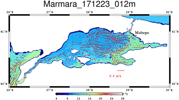
Fig. 1 Location of Maltepe coast where Mediterranean fish species were observed to surface, also showing TSSMOD currents and temperature at 12m depth on 23 December 2017.
Thanks to the present operational results displayed at the present TSSMOD site, we have observed a candidate event showing the impact of the shallowing interface in the Marmara Sea. Recent reports in news media have indicated that species normally living at depths of ~40m occupied by Mediterranean water (vatoz, kalkan, kalamar) have suddenly appeared in surface waters near Maltepe coast of İstanbul (Fig.1), the particular fish seeming relatively inactive and shocked.
Such events need detailed studies linking them to particular influences of marine and atmospheric dynamics. The particular fish surfacing event of 24 December 2017 reported in news media actually has lasted during 22-25 December 2017, when the upper layer of the TSS carrying water of Black Sea origin was affected by strong easterlies. Fig. 1 shows a strong gradient of temperature created in the eastern part of the TSS at 12m depth, with water of ~14.5ºC temperature (typical of Mediterranean water)in the east separated from the colder waters of ~12ºC (Black Sea water) towards the west.
The near-surface salinity distribution at 12m depth, shown in Fig. 2 clearly displays the eastern part of the basin with 32-33 psu salinity, characterized by Mediterranean water, while the west has 21 psu salinity, with a sharp front in between, indicating an upward tilt of the interface towards the east. At the surface (Fig. 3), the upwelled salinity reaches 25-26 psu, while the wind seems to have generated westward surface currents and a tilt of the free surface, dropping by 30cm between the western and eastern parts of the Marmara Sea.
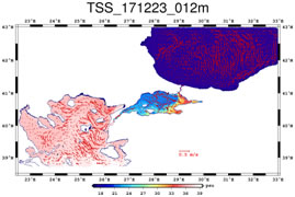
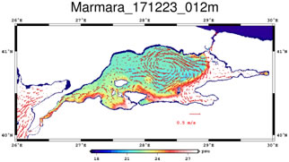
Fig. 2 TSSMOD salinity and currents at 12m depth on 23 December 2017 (a) in the entire model domain, (b) in the TSS region.
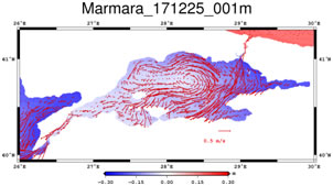
Fig. 3 TSSMOD forecastson 25 December 2017: (a) surface salinity and currents (b) sea surface height and currents in the TSS region.
The fine resolution TSSMOD results enable observing important details near the fish surfacing site of the Maltepe coast and establish links to the Bosphorus flows (Fig. 4)and especially the “Bosphorus Jet” normally observed in the region but apparently slowed down during the observation period. The warm area (light green) of Mediterranean water in the east have been enlarged from 23 to 25 December 2017, while the colder water (light blue) of Black Sea origin have receded further west, showing that the upper layer has become shallower and the deeper waters have been getting closer to the surface.
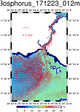
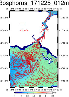
Fig. 4 Near field temperature and current variations at 12m depth near the Marmara Sea exit region of the Bosphorus, (a) 23 December 2017, (b) 25 December 2017.